|
|||||||||||||||||||||||||||||||||||
 |
|||||||||||||||||||||||||||||||||||
|
|
|||||||||||||||||||||||||||||||||||
 |
|||||||||||||||||||||||||||||||||||
![Map of Park — Click to enlarge •]• Seaside vegetation in Punta Holandès © sogestour](http://www.particuba.net/villes/guanahacabibes/images/MapaParque720.jpg) |
|||||||||||||||||||||||||||||||||||
|
|||||||||||||||||||||||||||||||||||
|
LODGING LIST HERE
|
REGIONAL MAP HERE
|
||||||||||||||||||||||||||||||||||
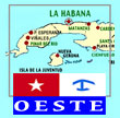
| PENINSULA DE GUANAHACABIBES There are no less than 121,572 hectares in the Peninsula de Guanahacabibes Biosphere Reserve estavlished by UNESCO in 1987, which includes a 39,901 hectare national park created by Cuba in 2001. Its name is Parque Nacional Península de Guanahacabibes and it encompasses two natural reserves created in 1963, Cabo Corrientes and El Veral. It's inhabited by 172 bird species from 42 families, 11 of which are endemic and 84 migratory. Experts consider that four of the seven species of marine turtles in the world survive in Guanacahabibes. Preserved here - on or near its 22 beaches - are some 140 archaeological sites related to the life of these indigenous people, who were known in the región as Guanahatabeyes. The aboriginal name comes in at least three spellings : Guanacabibes, Guanacahibes or even Guanahatabibes which all mean "place where the iguanas lived". It's one of the Cuban places where only the sun marks the time, where no one rushes, where some live half-dressed, no shoes and where almost every rock, nook and cranny has a story to tell, especially since one remembers it was on the path of the ships which carried the stolen riches from pre-Columbus America to a Spain which was run by christian extremists. For most of these colonial ships, going from the "New World" to Old Europe meant sailing by the peninsula where pirates awaited — not to beg or borrow but to steal the whole loot of gold, silver and stones. THE PORTAL To get here from Pinar del Rio, one passes through lovely scenery on the "carretera Panamericana" as it was planned to be renamed by Batista cronies who wanted to give the main Central American highway an extension through Cuba. That idea went out the door in 59 but the tobacco fields, the world-famous Vuelta Abajo has remained, sparsed by drying installations on lovely green carpets. Slowly the cattle works the land which gives rice, grains and greens to feed guajiros, tabacaleros and their families who have moved from bohios to casas de mamposteria — the wooden shack of yesteryear giving way to the cement house. GETTING HERE IS HALF THE FUN Barely 22 kilometers (13 miles) south of the town of Pinar del Rio, travellers cross San Juan y Martinez (superb village and HQ of the tabaco leaf) then Sabalo; here they are at the entrance of Parque nacional de Guanahacabibes spreading where the Caribbean Sea meets the Yucatan Strait. The road then leads to the regional townshi (municipio) of Sandino which starts at the town named Isabel Rubio. From there, one has a choice : either go straight west through the villages of Sandino, La Fe (pop. 600, once a port and sawmill for wood cut in Cabo San Antonio; in 1935-40, a US seaplane base) to Manuel Lazo, a total of 40 km. Or do like no one else does — head to the unknown — and aim south to bypass Sandino to another fork, a right turn towards Sitio de Santa Barbara on to Cortés 18 km south; then through La Conchita, La Grifa, Babineyes (maybe a 25-km return detour to La Furnia, La Yana and Cabo Francès ?) then Covadonga and Las Martinas to end up in Manuel Lazo, a total of 52 km. From here, the two roads join to La Bajada some 137 km southwest of Pinar del Rio and 281 km de La Habana. Here travellers find a National Park control point with its large wall map, guides and some local fishermen : the Bay of Corrientes stretches ahead. This is where one chooses to either : • turn left and ride this lovely partially-shaded 14 km road along the bay (on passenger side) to Maria la Gorda. • or go straight ahead on a 60-km lonely but superb road all the way to the end of Cuba at the Roncali lighthouse in Cabo San Antonio — the sea is on the left and there is nothing to see (no services, buildings, nada) but nature. The road was finished with tar on gravel in January 2009. THERE'S MORE Geographically speaking, the peninsula's nature stretches north. From the town of Sandino, one can ride to Punta Colorada a point eroded by centuries of sea and wind which advances on the Bay of Guadiana while splitting the Garnacha cove from the Picado cove on its south side; there is a 1-km beach hugely popular in summer, deserted in winter called Playa Colorada (altogether some 33 km from the town of Sandino). From this spot, one has an absolutely fabulous and totally unique view unlike any other in the Caribbean : the north coast of the Peninsula de Guanahacabibes. While in this area, closer to Sandino, there is a large water reserve and freshwater lake with a 3 sq mi area named Laguna Grande. Trout fishing, horseback riding and even hunting in nearby El Limon reserve can be organized through the Izlazul property on the lake side. Sources : Pedro Luis Hernandez Perez, Grupo Espeleologico Guaniguanico, Pinar del Rio dans El Explorador + www.italia-cuba.speleo.it + ecured + granma.cu
LOCATION Exactly : 21º 58’ latitude North and 84º 30’ longitude West. Limits : North, the gulf of Guanahacabibes and the townships of Mantua and Guane; East, the cove of Cortés and the port of Guane; South, the Caribbean Sea; West, the Yucatán Straight Served by a river, the Cuyaguateje at its eastern end, its northern limit the Cordillera of Guaniguanico in the summits (Alturas) of Pizarras del Sur where mostly pine trees (male and female) abound : the Pino Macho (Pinus caribaea Morel) and the Pino Hembra (Pinus tropicalis Moric). Further, going northwest, a wall of limestone makes up the Sierra de Paso Real and on the other side, the Sierra de Guane. AREA, POPULATION Its territory covers some 1711,2 km2 where some 40,314 Cubans live in a ratio of 24 residents per Km2; among them 22,510 or 55.83% live in communities. Villages with more than 1,000 people : Sandino (admin town), Manuel Lazo, Las Martinas and Cortés. TRANSPORTATION Viazul busses leave at 09h00 and 14h30 daily from Havana and arrive Pinar del Rio at 13h00 and 17h55 Sked here. From there, it's taxi in CUC, or shared in CUP or car rental or with luck, a bus or two. |
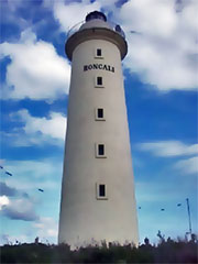
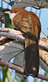
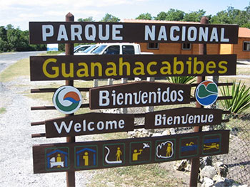 Welcome sign at La Bajada and its park management office : here one chooses to follow the peninsula straight to Faro Roncali in Cabo San Antonio 60 km ahead or turn left and go for the 14 km leading to Maria la Gorda. © Embajada de Francia 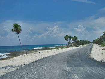 The road going to the very end of Cuba stretches for over 60 km from La Bajada, along deserted beaches (as is the whole peninsula, Ursula !). These playas (windy with strong undercurrents) are named Antonio, Perjuicio and La Barca, then Punta Holandès, places named Caleta Larga and Los Cayuelos, then the lighthouse named Roncali and its rather new Villas Cabo San Antonio and the end is at Punta Cajon (office, dock and marina). Detailed map here © laurha, flickr.com 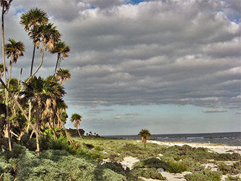 From Punta del Holandès, the seaside vegetation is unique and impressive (as in panoramic photo on top of page); alas as elsewhere on this planet, trash from transport and (yes...) leisure boats abound on shore © Embajada de Francia 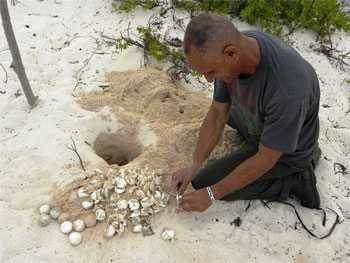 Roberto Varela, on one of six monitoring spots, protecting three varieties of turtles which nest on the Peninsula every 2-3 years. More than 2,500 volunteers and some 800 tourists have lent a hand. © dorelis canivel, juventud rebelde 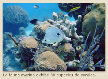 Diving off Playa Maria la Gorda to enjoy 38 species of coral formations © 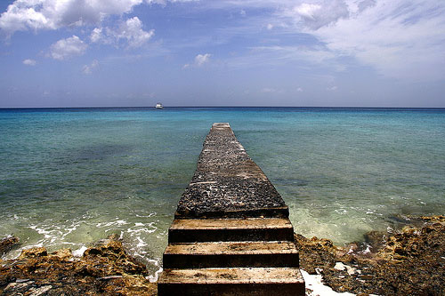 A rompeola - (rompe, break + ola, wave), this type of wavebreaker is unique in Cuba and it's in Maria la Gorda, voilà ! © unk 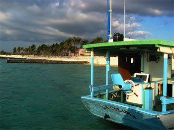 Maria la Gorda resort, a breaker and one of two diver transporters, this one named after the nearby port where it was built, La Coloma © partwish, picasa 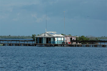 In the middle of nowhere, a langosta (lobster) midway house, solar-powered © henk.jamin, flickr.com 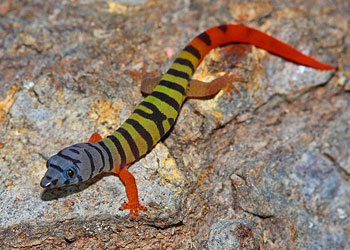 One of many specimens of fabulous fauna in Western Cuba, as discovered by jpburgess © jpburgess on flickr 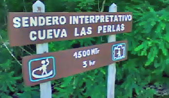 From the visitors centre in La Bajada, one can enjoy a 1,5 km 3-hour trek on Sendero Interpretativo which leads to the visit of a 300-meter long cavern with 8 impressive galeries to discover with a guide © sogestour. |
||||||||||||||||||||||||||||||||||
|
|||||||||||||||||||||||||||||||||||
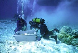 130 FOUND, 1,211 TO GO La Habana (Prensa Latina) — Some 167 museologists from 12 countries noted the high value of Cuba's underwater archeology, due to its unprecedented capacity to preserve the submerged cultural and patrimonial wealth at the Fourth Ibero-American Meeting of Museums and Historic Centers in Havana in May 2007. The frigate Arrow, from which 2,000 pieces of English chinaware were recovered, and the brigantine Ines de Soto, which carried 33,000 of the first coins minted in the Americas, both from the 16th century, are examples of the wealth resting in the Caribbean sea bottoms. "We have 1,341 references of shipwrecks documented by historians, but just 130 have been discovered over the past 20 years, said Lopez, who has more than three decades' experiences as an archeologist. Adverse weather conditions and constant attacks by corsairs and pirates in the Caribbean, in addition to bad sailing conditions in the 16th century, contributed to a large number of shipwrecks off Cuban coasts. Lopez noted Carisub, Cuba's non-lucrative interest in archeology, backed by prominent personalities like French oceanographer Jacques Cousteau (1910-1997), who worked with Cuban scientists for several years. Carisub S. A. was founded in 1980 by the Tourism Research office and CEF, the Cuban State's Finance Committee. It belonged to CIMEX at first. During its 20 years of existence until the entity was ceded to SERMAR (Cuban army), it carried out more than 100 underwater searches. Carisub was not the only institution dedicated to undersea exploration in Cuba : some 10 other entities (Instituto de Oceanologia, Grupo de Rescate Subacuatico, Grupo de Rescate de Valores No Circulantes, INTUR, Grupo Batabano, Geocuba, Geomar, Antillana de Salvamento, etc) also did and are still active, each with its assigned territory. Video documentaries about Carisub's work have included : 1. El desastre del Barcaíztegui (1980-1981), by René David. 2. La isla del tesoro azul (1984-1985), by Fernando Pérez & Roger Montañés. 3. ¡Hola mar! (1987-1988). Instituto Cubano de Radio y Televisión & Carisub, S. A. 4. El naufragio de la Almiranta (1990), by Jorge Soliño. 5. La flota de Cervera (1991), by Jorge Soliño. 6. Hombres trabajando (1991), by Jorge Soliño. 7. Historias sumergidas (12 capítulos) (1991), by Rogelio París. 8. Cuba: The Lost Treasure (1992-1993), National Geographic Society (NGS), EUA. 9. La Isla del Tesoro (2001-2002), by María Monique, France. Source |
|||||||||||||||||||||||||||||||||||
|
|||||||||||||||||||||||||||||||||||
|
BIRDS, LOCAL FAUNA & CAVES
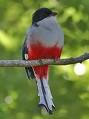
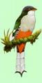
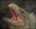
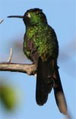
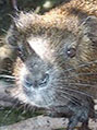
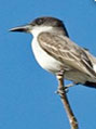
Among flying species in the area : the Cartacuba, Tocororo (Cuban Trogon), Sijú platanero (Cuban Pygmy-Owl), Zunzuncito (Bee Hummingbird), some of which use a migratory corridor along with some 50 other species plying the north-south routes (like the snowbirds they are) stopping for food and drink in coastal wet areas and marshes and adopting Cuban winters — just like the humans they entertain during Canadian summers. Guanahacabibes is also the home of 35 species of reptiles and the habitat of many iguanas and other reptiles. Geolocally speaking, the coral reef is very-well conserved thanks to two protected zones : El Veral and Cabo Corrientes. There are dry forests on the peninsula, sometimes humid with mangroves, some prairie-like land, rocky areas, some dunes and many coral reefs. There are many limestone land masses pierced with many caves where finds of archeological importance are continually effected by local authorities. Unique to Cuba, the marmot-like Jutía Conga (Capromys pilorides) as well as the Cuban Boa and Iguana are present; unique (endemic) plants also abound. The National park is vital to numerous migratory species thanks to its proximity to the Yucatan Peninsula. In a sector where sand and mangroves are close to each other, the forests near Maria la Gorda harbour the Great Lizard-Cuckoo (Coccyzus merlini), the Ruddy Quail-Dove (Geotrygon montana), the Yellow-headed Warbler (Teretistris fernandinae) and the Giant Kingbird. Some 500 meters from the hotel resort, there are two interesting water spots where these can be seen : the Charadrius vociferus is a regular migrator. Among some endemic warblers observed locally : the Archilochus colubris in migration and the Grey-faced Quail-Dove (Geotrygon caniceps). Source : ornithomedia.com |
|||||||||||||||||||||||||||||||||||
| HEED THE HINTS IN THIS FINE PRINT ::: Make sure that in your first email or phone call you specify that you want to book a room in that particular casa and that you will reconfirm your booking on arrival in Cuba. Unless you only want a room in any house which may be of the same quality, not the specific casa you booked through photos on these websites ::: So as to not abandon expecting owners with empty rooms, reconfirm (or call ahead to cancel) your booking by phone as soon as you can after arriving in Cuba ::: Please write or phone a casa owner to cancel a booking. As late as it may seem, it allows them a chance to rebook. ::: Children under the age of 16 may share a bedroom with adults for free. Specify the child's age when booking. ::: At the end of the casa name, the V signals the casa was suggested by travelers or owners but not verified by the website staff. If you try it and like it, write us about it. ::: Unless otherwise mentioned, the average room rates and service prices are : 20-25cuc per bedroom per night [up to 40+ for 4 in a room]; breakfasts 3-5cuc, dinners 7-10cuc. ::: Any casa particular anywhere in Cuba must have a hot water shower, otherwise it cannot have a permit to rent ::: Please share your Complaints, comments & suggestions webmaster [@]cubacasas.net |
|||||||||||||||||||||||||||||||||||
|
BOOK BY PHONE • From Canada and the USA : 011 53 (add phone # preceded by 48 for Sandino) • From Europe, Great Britain, Scandinavia and Mexico : 00 53 (add phone # preceded by 48 for Sandino) ••• HOW TO DIAL A CUBAN PHONE NUMBER HERE ••• CELL PHONE NUMBERS on our town lists and casa pages are preceded by 05 for calls originating Havana; from anywhere else in Cuba, dial 01 + the 8 digits of the cell. BOOK BY EMAIL : |
||||||||||||||||||||||||||||||||||
VILLA AZUL V One ac bedroom with two double beds, meals Calle A, No. 36 in La Bajada, 14 km from Maria la Gorda, 500 m from the national park visitors centre. Map. Tel. (48) 75-1017 Cel 52 78 20 47  |
|||||||||||||||||||||||||||||||||||
| VILLA CORAL - MARTA V Three ac bedrooms with two beds, meals Calle A, No. 20 in La Bajada, 14 km from Maria la Gorda, next to the two previous, near the national park visitors centre. Map. Cel 55 91 29 11 @ 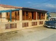 |
|||||||||||||||||||||||||||||||||||
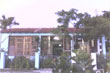
| MOTEL ALEXIS - CARMEN CORDERO Two aircon bedrooms, shared bathroom, patio Zona L 33, one block off main road in Sandino - 30 mins. (52 km) from the national park visitors centre in La Bajada. Map Tel. (48) 42-3282 or (48) 42-3557  |
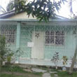
VILLA EDILIA - TONY Three aircon bedrooms, ensuites, excursions Zona M, casa 41, near Policlinico in Sandino - 30 mins. (52 km) from the national park visitors centre. Map. Tel. (48) 42-3843 cel. 52 63 73 59 @ 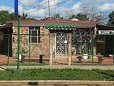 |
||||||||||||||||||||||||||||||||||
| MOTEL SUNSO y GINA Two aircon bedrooms, ensuites, patio Zona O, casa 22 in Sandino - 30 mins. (52 km) from the national park visitors centre in La Bajada. Map. Tel. (48) 42-3131  |
VILLA MOTEL ROGELIO One ac bedroom with two double beds, meals Zona O, casa # in Sandino - 30 mins. (52 km) from the national park visitors centre in La Bajada. Map. Tel. (48) 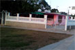 |
||||||||||||||||||||||||||||||||||
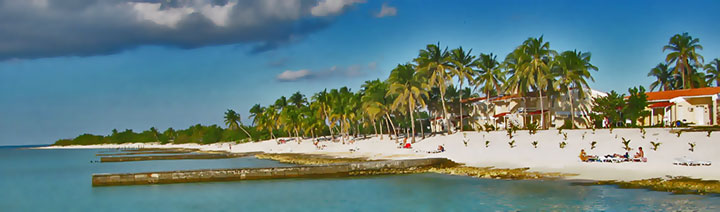 The beach off Hotel & C.I.B. Maria la Gorda © cuba-diving.de |
|||||||||||||||||||||||||||||||||||
| HOTEL & C.I.B. MARIA LA GORDA 35 bedrooms + 20 bungalows sitting on the bay of Corrientes, 14 km from La Bajada Map Tel. (48) 77-8077  |
VILLAS CABO SAN ANTONIO
In one of the most deserted spots in Cuba, 16 modern chalets off the beach, 60 km from La Bajada. Map Tel. (48) 75-7656  |
||||||||||||||||||||||||||||||||||
| VILLAS LAGUNA GRANDE 12 cabañas on namesake lake, close to hitherto unknown bay of Guadiana, 77 km from La Bajada. Map Tel (48) 84-3453 or 84-2430  |
|||||||||||||||||||||||||||||||||||
 |
Content & photos © sogestour Updated |
||||||||||||||||||||||||||||||||||
 |
|||||||||||||||||||||||||||||||||||